
Forty geological sites to visit via virtual reality
Staff of the laboratory of virtual reality for Earth Sciences, Geovires of the department of “Scienze dell'Ambiente della Terra” of the University of Milano-Bicocca provide “Virtual Outcrops”
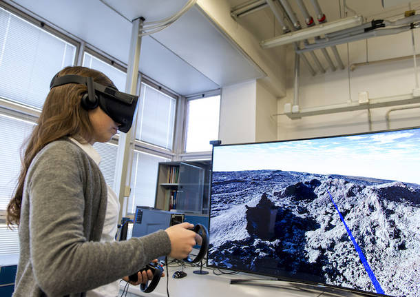
From Greece to Iceland, from Italy to the Maldives. All in a touch. Students, researchers or the simply curious will be reunited, with a click, with the slopes of active volcanoes, seabeds, long active faults or within volcanic craters. Real environments photographed with drones and accessible through virtual reality directly from home.
Staff of the laboratory of virtual reality for Earth science, Geovires (https://geovires.unimib.it/) of the department of the University of Milano-Bicocca, in fact decided to provide forty geological sites, called “Virtual Outcrops”, to allow people to explore in first-person geological sites of various parts of the world. It will be possible to make real geological excursions through virtual reality or 360-degree video, by using special viewers connected to smartphones or laptops. Visitors that don’t have these special viewers can explore websites in 3D.
Every Virtual Outcrop is enriched with a special explanation, in English, and by the indication of scientific publications of reference so it can guide users through the fruition and the understanding of the geological website. The scientific aspects are a lot and will be studied: from the active tectonics to volcanoes, from seabeds of the Indian Ocean up to fossils in the laboratory. The sharing of Virtual Outcrops will also continue after the pandemic, with the purpose to put science at the disposal of everyone. Therefore, it will be always possible to explore locations that, in many cases, they would hardly be accessible due to their location in remote regions of the planet.
“We believe that in this period especially, it’s important to share useful material in order to spread knowledge and make it usable and available to as many people as possible, in particular using virtual reality techniques. Hence the decision to set up a website, in collaboration with others institutes and organisations both Italian and foreign, which have been working for a long time with virtual reality as part of shared projects,” explained Fabio Bonalli, one of the creators of the initiative and researcher of Structural Geology.
The institutes collaborating with GeoVires are the Interuniversity Center CRUST, the University of Insubria in Varese and the Osservatorio Etneo-INGV in Catania at Italian level while internationally the University of Athens and the European Geosciences Union.
“The Laboratory of Cartography and Drones of the Osservatorio Etneo – INGV has made available a series of virtual outcrop models made through SfM (Structure from Motion) photogrammetric techniques for their spread in virtual realities to the colleagues of the Laboratory of Virtual Reality for Earth Sciences of the University of Milano-Bicocca. For years, the drones have been showing great potentialities as indispensable tools for the environmental monitoring, the scientific research and the divulgation. We are therefore proud to share with other colleagues the materials we made, with the common goal of increasing the opportunity to visit unique and geologically very interesting sites like those that characterize the Sicilian area,” explained Emanuela de Beni, researcher of INGV, who took part in the project together with his colleague Massimo Cantarero.
GeoVires Lab is the result of the experienced gained from two previous projects, Argo3D (http://argo3d.unimib.it/) and 3DTeLC, coordinated by Alessandro Tibaldi, professor of Structural Geology. On that occasion, they developed software focused on allowing the students of the University of Milano-Bicocca to use an immersive virtual reality for future geological studies with a navigation on very high-resolution models capable of ensuring an innovative and captivating teaching.
“This laboratory represents an extremely innovative initiative of scientific communication, based on the use of very high-resolution pictures, taken by drones during a series of research expeditions in Island, on the isle of Santorini and on Etna, to which I recently took part. It is a strategy of virtual teaching that is particularly suitable to be used during lockdown periods but that will probably represent one of the cornerstones of the teaching in the geological and environmental field also after the return to normality,” said Federico Pasquaré Mariotto, professor of Communication of the Environmental Emergencies of the University of Insubria.
TAG ARTICOLO
Dalla Home
Ferno
Voto di scambio e ‘ndrangheta a Ferno, il carabiniere che indagò: “Gesualdi non voleva incontrare De Castro”

Varese
Il consiglio comunale di Varese conferma la bocciatura all’ampliamento del centro padel di Lissago
Salute
“Siamo affetti da fibrosi cistica, ma il farmaco che ci serve è irreperibile”

Gallarate
Tavernari, Coltro e l’Alfabeto del Contemporaneo: tris di nuove mostre al Maga
La community di VareseNews
Loro ne fanno già parte
Ultimi commenti
Alberto Gelosia su Ilaria Salis candidata alle europee con Alleanza Verdi Sinistra nel collegio NordOvest
lenny54 su I no vax sono tornati a colpire in provincia: imbrattati i muri della redazione di Varesenews
malauros su I no vax sono tornati a colpire in provincia: imbrattati i muri della redazione di Varesenews
Felice su I no vax sono tornati a colpire in provincia: imbrattati i muri della redazione di Varesenews
PaoloFilterfree su A Varese Salvini prova a ricucire passato e futuro della Lega, ma Bossi non c'è
axelzzz85 su A Varese Salvini prova a ricucire passato e futuro della Lega, ma Bossi non c'è


Accedi o registrati per commentare questo articolo.
L'email è richiesta ma non verrà mostrata ai visitatori. Il contenuto di questo commento esprime il pensiero dell'autore e non rappresenta la linea editoriale di VareseNews.it, che rimane autonoma e indipendente. I messaggi inclusi nei commenti non sono testi giornalistici, ma post inviati dai singoli lettori che possono essere automaticamente pubblicati senza filtro preventivo. I commenti che includano uno o più link a siti esterni verranno rimossi in automatico dal sistema.